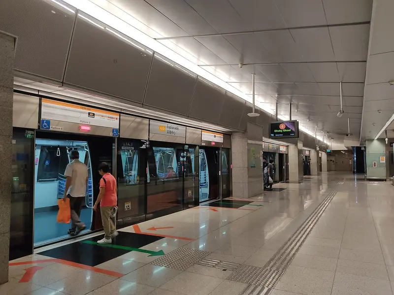
Which exit?
See on map-
City Harvest Church
This exit is the nearest one to these places, in a straight line from the exit. It is not what LTA’s signs say.
Show this exit in Google Maps -
The Burger Bar · 47 m
- The Burger Bar
- Chic-a-boo
- Bangkok Jam
Places in a straight line from this exit: LTA’s bus stops, the hotel, pharmacy and money changer registers, and OpenStreetMap’s places to eat. It is not what LTA’s signs say.
Show this exit in Google Maps -
Near War Memorial Park, Singapore · 114 m
- War Memorial Park, Singapore
- Burger King
- Omu
Places in a straight line from this exit: LTA’s bus stops, the hotel, pharmacy and money changer registers, and OpenStreetMap’s places to eat. It is not what LTA’s signs say.
Show this exit in Google Maps -
Esplanade – Theatres on the Bay
This exit is the nearest one to these places, in a straight line from the exit. It is not what LTA’s signs say.
Show this exit in Google Maps -
Burger King · 29 m
- Burger King
Places in a straight line from this exit: LTA’s bus stops, the hotel, pharmacy and money changer registers, and OpenStreetMap’s places to eat. It is not what LTA’s signs say.
Show this exit in Google Maps -
Singapore Armed Forces Warrant Officers' and Specialists' Club · Raffles Hotel +2
- Singapore Armed Forces Warrant Officers' and Specialists' Club
- Raffles Hotel
- Peoples' Defence Force Headquarters
- Mint Museum of Toys
This exit is the nearest one to these places, in a straight line from the exit. It is not what LTA’s signs say.
Show this exit in Google Maps -
War Memorial Park, Singapore · Civilian War Memorial
This exit is the nearest one to these places, in a straight line from the exit. It is not what LTA’s signs say.
Show this exit in Google Maps
7 exits · 7 with a map position · exits and positions: LTA
Right now at this station
Train service, lifts and crowds: LTA DataMall, live. Weather: NEA two-hour forecast (data.gov.sg), for the forecast area nearest the station.

Taxi stands near the exits
- Raffles Blvd at Suntec City Mall Taxi stand · barrier-free
- Temasek Blvd at Suntec Tower 5 Taxi stand · barrier-free
- Stamford Rd along driveway of Raffles City Taxi stand · barrier-free
- North Bridge Rd along driveway of Raffles City Taxi stand · barrier-free
LTA DataMall Taxi Stands (Singapore Open Data Licence): stand or stop and barrier-free as LTA lists them. Distances are in a straight line from the exit.
Buses at the exits
Esplanade Stn Exit F
- 56 to Promenade Stn/Pan Pacific…
- 57 to Bt Merah Int…
- 100 to Ghim Moh Ter…
- 107 to Shenton Way Ter…
- 107M to Opp Suntec Convention Ctr…
- 961 to Woodlands Temp Int…
All 7 services
- 961M to Woodlands Temp Int…
Opp War Memorial Pk
- 10 to Kent Ridge Ter…
- 10e to Aft Straits BlvdExpress…
- 57 to Bt Merah Int…
- 70 to Shenton Way Ter…
- 196 to Clementi Int…
- 196A to Prince Edward Rd Stn Exit 2…
All 15 services
- 196e to Prince Edward Rd Stn Exit 2Express…
- 648 to Prince Edward Rd Stn Exit 2…
- 650 to Prince Edward Rd Stn Exit 2…
- 652 to Prince Edward Rd Stn Exit 2…
- 656 to Prince Edward Rd Stn Exit 2…
- 660 to Prince Edward Rd Stn Exit 2…
- 660M to Prince Edward Rd Stn Exit 2…
- 663 to Prince Edward Rd Stn Exit 2…
- 665 to Prince Edward Rd Stn Exit 2Express…
Raffles Hotel
- 14 to Bedok Int…
- 14e to Blk 139Express…
- 16 to Bedok Int…
- 16M to Bedok Int…
- 36 to Changi Airport Ter 2…
- 36B to Bef Seaside Residences…
All 32 services
- 77 to Promenade Stn/Pan Pacific…
- 106 to Shenton Way Ter…
- 111 to Ghim Moh Ter…
- 130 to Shenton Way Ter…
- 131 to Bt Merah Int…
- 131A to Aft Straits Blvd…
- 133 to Shenton Way Ter…
- 167 to Bt Merah Int…
- 502 to Soon Lee Bus PkExpress…
- 502A to Downtown Stn Exit EExpress…
- 518 to Pasir Ris IntExpress…
- 518A to Bayfront Stn Exit AExpress…
- 648 to Prince Edward Rd Stn Exit 2…
- 650 to Prince Edward Rd Stn Exit 2…
- 652 to Prince Edward Rd Stn Exit 2…
- 656 to Prince Edward Rd Stn Exit 2…
- 660 to Prince Edward Rd Stn Exit 2…
- 660M to Prince Edward Rd Stn Exit 2…
- 663 to Prince Edward Rd Stn Exit 2…
- 665 to Prince Edward Rd Stn Exit 2Express…
- 681 to Opp Blk 477A…
- 683 to Blk 649…
- 857 to Yishun Int…
- 857B to Aft Promenade Stn Exit C…
- 960 to Promenade Stn/Pan Pacific…
- 960e to Promenade Stn/Pan PacificExpress…
Express services cost more: bus fares.
LTA DataMall Bus Stops and Bus Routes (read 2026-10-02) and Bus Arrival, Singapore Open Data Licence. Stops within 150 m of an exit, in a straight line. Arrival times are LTA's estimates; first and last buses are LTA's timetable for the stop.
Pharmacies, money changers and hotels
- Watson's Personal Care Stores Pte Ltd (Suntec City) Pharmacy
- Guardian Pharmacy (New Suntec City) Pharmacy
- Watson's Personal Care Stores Pte Ltd (Raffles City) Pharmacy
- BEACH ROAD HOTEL (1886) LTD. Money changer
- SILVER RIVER MONEY CHANGER Money changer
- CENTRAL EXCHANGE Money changer
- JW Marriott Hotel Singapore South Beach Hotel · 634 rooms
- Swissotel The Stamford, Singapore Hotel
- Raffles Hotel Singapore Hotel · 115 rooms
Up to three of each within 400 m of an exit, nearest first, in a straight line. From the registers of HSA (pharmacies), MAS (money changers) and the Hotels Licensing Board, Singapore Open Data Licence. No hours, rates or prices: the registers carry none.
When it’s busy
Busiest from 18:00 to 19:00 on weekdays and from 16:00 to 17:00 on weekends and public holidays.
100th of 184 stations by taps in August 2026Taps in and out at this station's fare gates in each hour of August 2026, from LTA DataMall (Singapore Open Data Licence). Each row is drawn against its own busiest hour; the darker bar is now.
 War Memorial Park, SingaporePark and garden · 95 m, nearest exit G
 Civilian War MemorialHistoric site · 108 m, nearest exit GSingapore Armed Forces Warrant Officers' and Specialists' ClubHistoric site · 140 m, nearest exit F
 City Harvest ChurchChurch · 212 m, nearest exit A
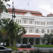 Raffles HotelHistoric site · 238 m, nearest exit F
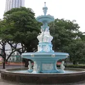 Tan Kim Seng FountainPublic art · 287 mPeoples' Defence Force HeadquartersHistoric site · 319 m, nearest exit FMint Museum of ToysMuseum · 356 m, nearest exit F

Within 800 m in a straight line from the station, not walking routes.
Places to eat near the exits
- Old Chang Kee
- Omu
- Mad for Garlic
- Burger King
- SoupCup Suntec City
- SaladStop
- The Burger Bar
- Starbucks
- Putien
- Uncle Fong Hot pot Restaurant 方叔叔重慶老火鍋
- Starbucks
- Wild Honey
The 12 closest of 145 within 300 m of an exit, nearest first, in a straight line. Not a ranking, and hours are not shown: check before you go. · © OpenStreetMap contributors (ODbL), data as of 6 May 2026
Nearby stations
- City Hall Station 340 m
- Promenade Station 540 m
- Bras Basah Station 680 m
- Bugis Station 820 m
- Bencoolen Station 860 m
- Clarke Quay Station 1.1 km
Distances are in a straight line from this station, not walking routes.