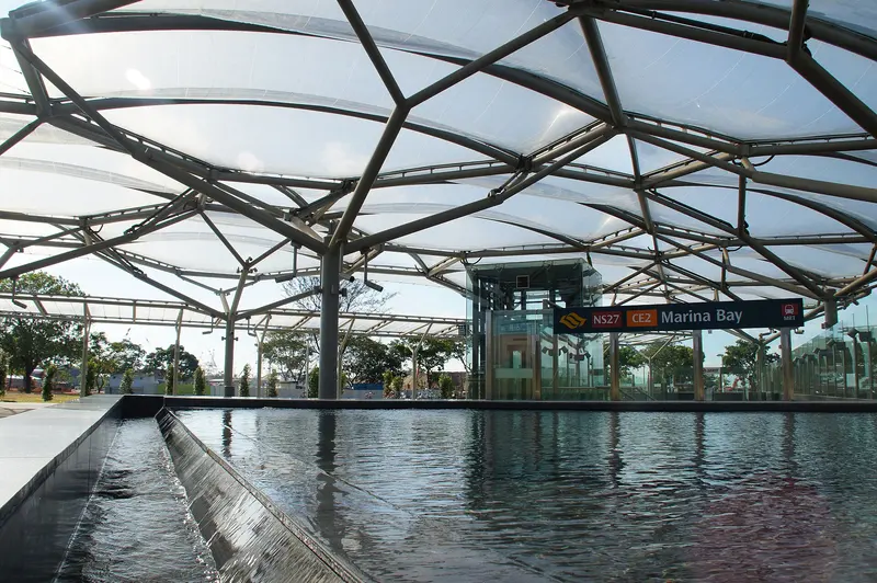
Which exit?
See on map-
Supergreen · 103 m
- Supergreen
- Chili Ban Mian and Char Quay Teow
- Malaysia Chiak!
- Hainanese Curry Rice
- Morning Grind
Places in a straight line from this exit: LTA’s bus stops, the hotel, pharmacy and money changer registers, and OpenStreetMap’s places to eat. It is not what LTA’s signs say.
Show this exit in Google Maps -
Taxi stand Bayfront Ave outside Marina Bay MRT Station · 34 m
- Marina Bay Stn
Places in a straight line from this exit: LTA’s bus stops, the hotel, pharmacy and money changer registers, and OpenStreetMap’s places to eat. It is not what LTA’s signs say.
Show this exit in Google Maps -
Bus stop Marina Bay Stn · 237 m
- Marina Bay Stn
Places in a straight line from this exit: LTA’s bus stops, the hotel, pharmacy and money changer registers, and OpenStreetMap’s places to eat. It is not what LTA’s signs say.
Show this exit in Google Maps -
Bus stop Aft Marina Gdns Dr · 367 m
- Aft Marina Gdns Dr
Places in a straight line from this exit: LTA’s bus stops, the hotel, pharmacy and money changer registers, and OpenStreetMap’s places to eat. It is not what LTA’s signs say.
Show this exit in Google Maps -
Bus stop Marina Bay Stn · 347 m
- Marina Bay Stn
Places in a straight line from this exit: LTA’s bus stops, the hotel, pharmacy and money changer registers, and OpenStreetMap’s places to eat. It is not what LTA’s signs say.
Show this exit in Google Maps
5 exits · 5 with a map position · exits and positions: LTA
Right now at this station
Train service, lifts and crowds: LTA DataMall, live. Weather: NEA two-hour forecast (data.gov.sg), for the forecast area nearest the station.

Taxi stands near the exits
- Bayfront Ave outside Marina Bay MRT Station Taxi stand · barrier-free
LTA DataMall Taxi Stands (Singapore Open Data Licence): stand or stop and barrier-free as LTA lists them. Distances are in a straight line from the exit.
Buses at the exits
Marina Bay Stn
- 97 to Tengah Int…
- 97e to Tengah IntExpress…
- 106 to Shenton Way Ter…
- 133 to Shenton Way Ter…
- 400 to Shenton Way Ter…
- 502 to Soon Lee Bus PkExpress…
All 29 services
- 502A to Downtown Stn Exit EExpress…
- 646 to Prince Edward Rd Stn Exit 2…
- 649 to Blk 489A…
- 651 to Blk 276B…
- 653 to Hillington Green Condo…
- 654 to Prince Edward Rd Stn Exit 2…
- 655 to Opp Blk 51…
- 657 to Blk 536…
- 661 to Opp Blk 476…
- 666 to Damai Stn Exit B…
- 667 to Blk 308…
- 668 to Blk 649…
- 670 to Blk 289…
- 671 to Opp Blk 266/The Rivervale…
- 672 to Blk 574…
- 673 to Bef Punggol Pt Stn…
- 674 to Blk 321…
- 675 to Opp Blk 953…
- 676 to Opp Blk 477A…
- 677 to Blk 111…
- 678 to Blk 649…
- 679 to Blk 471A…
- 684 to Blk 816B…
Express services cost more: bus fares.
LTA DataMall Bus Stops and Bus Routes (read 2026-10-02) and Bus Arrival, Singapore Open Data Licence. Stops within 150 m of an exit, in a straight line. Arrival times are LTA's estimates; first and last buses are LTA's timetable for the stop.
Pharmacies, money changers and hotels
- Watson's Personal Care Stores Pte Ltd (Marina Bay Financial Centre) Pharmacy
- ISHWARYA MONEY CHANGER Money changer
Up to three of each within 400 m of an exit, nearest first, in a straight line. From the registers of HSA (pharmacies), MAS (money changers) and the Hotels Licensing Board, Singapore Open Data Licence. No hours, rates or prices: the registers carry none.
When it’s busy
Busiest from 18:00 to 19:00 on weekdays and from 17:00 to 18:00 on weekends and public holidays.
117th of 184 stations by taps in August 2026Taps in and out at this station's fare gates in each hour of August 2026, from LTA DataMall (Singapore Open Data Licence). Each row is drawn against its own busiest hour; the darker bar is now.
 Singapore Conference HallTheatre and venue · 628 m
 Lau Pa SatMarket · 645 mSingapore PolytechnicHistoric site · 749 m
Within 800 m in a straight line from the station, not walking routes.
Places to eat near the exits
- Supergreen
- Chili Ban Mian and Char Quay Teow
- Hainanese Curry Rice
- Malaysia Chiak!
- Morning Grind
- The Social Space
- Yong Peng Fish Ball Noodle
- Starbucks
- Workspace Expresso Bar Financial Centre
- A Poke Theory
- Chiak!
- PizzaExpress
The 12 closest of 41 within 300 m of an exit, nearest first, in a straight line. Not a ranking, and hours are not shown: check before you go. · © OpenStreetMap contributors (ODbL), data as of 6 May 2026
Nearby stations
- Downtown Station 380 m
- Shenton Way Station 490 m
- Bayfront Station 780 m
- Prince Edward Road Station 870 m
- Raffles Place Station 910 m
- Telok Ayer Station 960 m
Distances are in a straight line from this station, not walking routes.